Main ethnic groups in Melbourne by statistical area (2016)
Main ethnic groups in Melbourne by statistical area (2016)
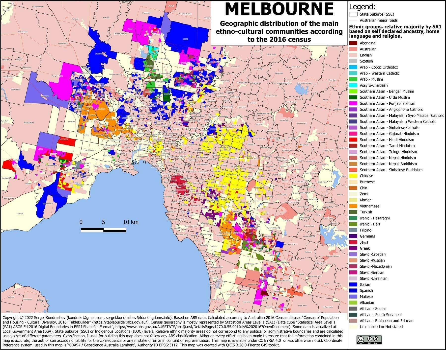
‘Just looked up my home suburb. Yep sounds about right’

Main ethnic groups in Melbourne by statistical area (2016)

‘Just looked up my home suburb. Yep sounds about right’
Geographical distribution of the main ethno-cultural communities in Israel and Palestine
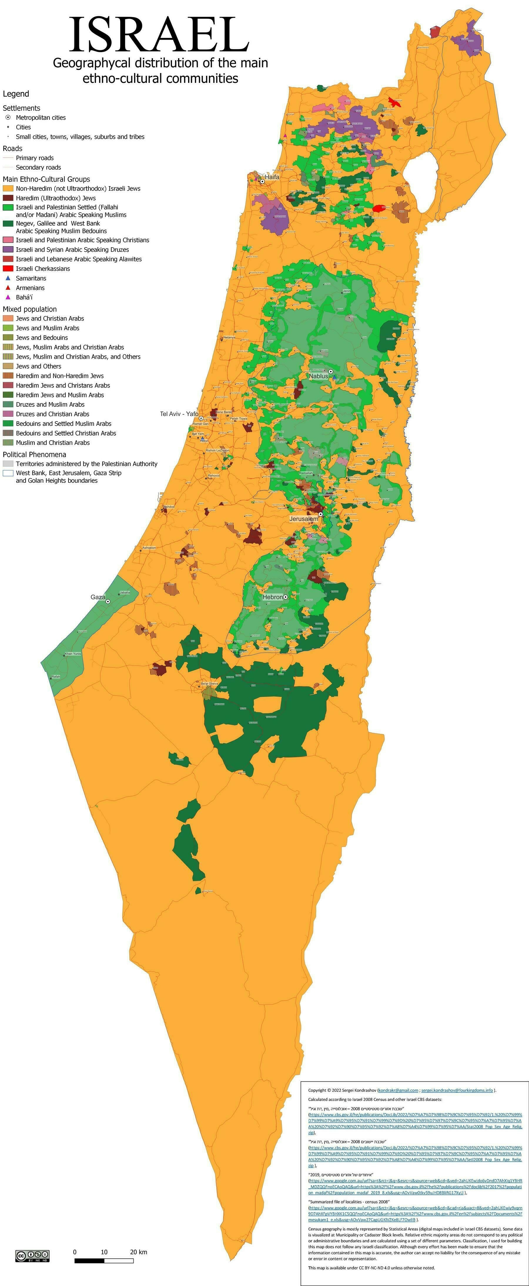
‘Man, Israel is tiny
Really is. Gaza is about the size of Manhattan and the Bronx put together, which is real tiny’
Main ethnic groups in Sydney by statistical area (2016)
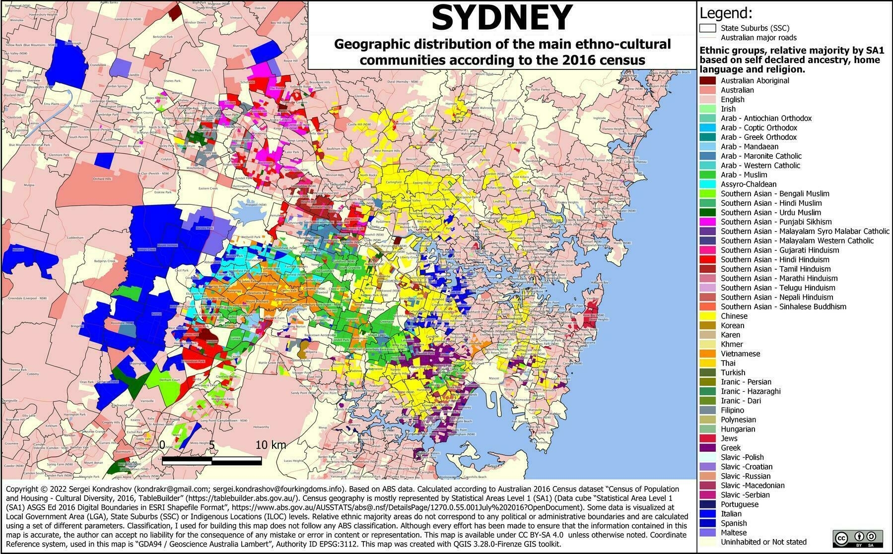
‘Wow, great map! Very interesting’
Indigenous Americans by U.S. state (2020)
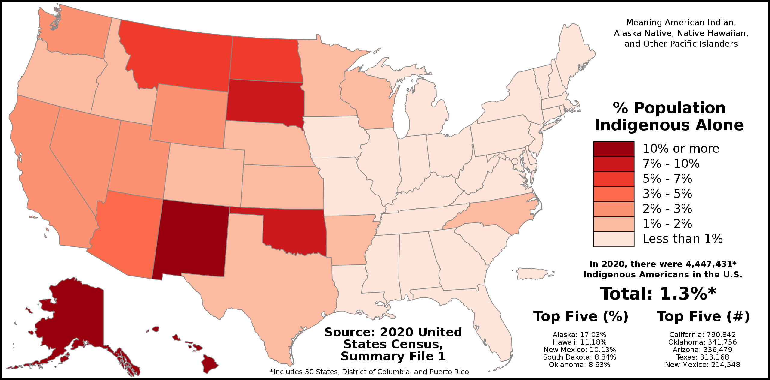
‘You guys really did a number on the indigenous east of the Mississippi river’
Major Ethnic Groups of Central Asia (1992)
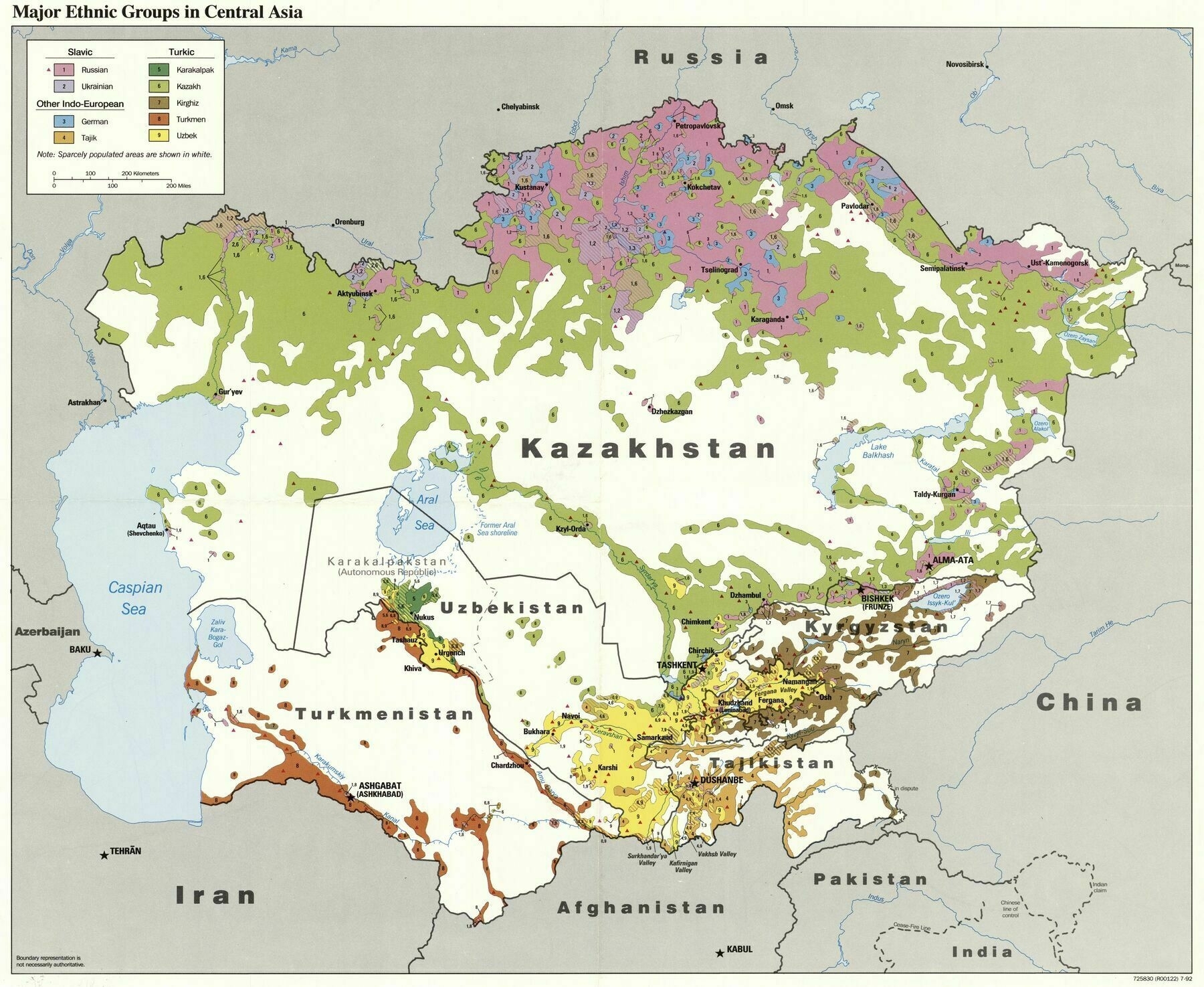
‘How did so many Germans end up so east?
Stalin had the Volga Germans deported’
1911 ethnographic map of Ontario and western Quebec
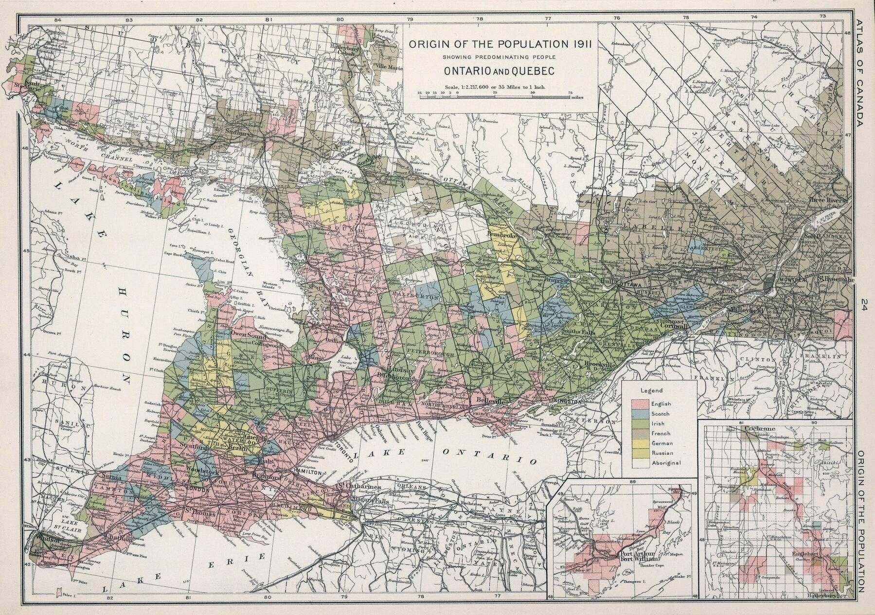
‘I think Windsor is the Irish green. I would say that the only Russian green is around Frederick House L. (in the corner inset)
I’m from Windsor, it’s French. There used to be a large population of French in the area and many of the street names are French, now locally pronounced with awful anglicized versions
I heard that a-lot of French Canadians have Irish blood from the huge influx of Irish into Quebec in the 1840’s. Is that maybe a reason for the green? Many of those people probably switched from Gaelic to French speaking, skipping the English part
While it’s true that many Irish immigrants in Quebec (or their descendants over several generations) assimilated into the Francophone majority, the Irish in Ontario overwhelmingly spoke English, even in areas where French was spoken
My guess is that was a 20th century phenomenon. The famine immigrants were from overwhelmingly Gaelic speaking areas in the west of Ireland, many had no English atall. It could well be that for many it was English they learned when they got to Canada
The Irish that settled in Montreal largely integrated the English speaking community. In the Quebec countryside, many married fellow Catholic French Canadians and eventually switch from Irish or English to French. Also, many Irish orphans were adopted by French Canadians and became French speaking. That was the case with my Irish great-great grandmother.’
1911 ethnographic map of Manitoba and Saskatchewan
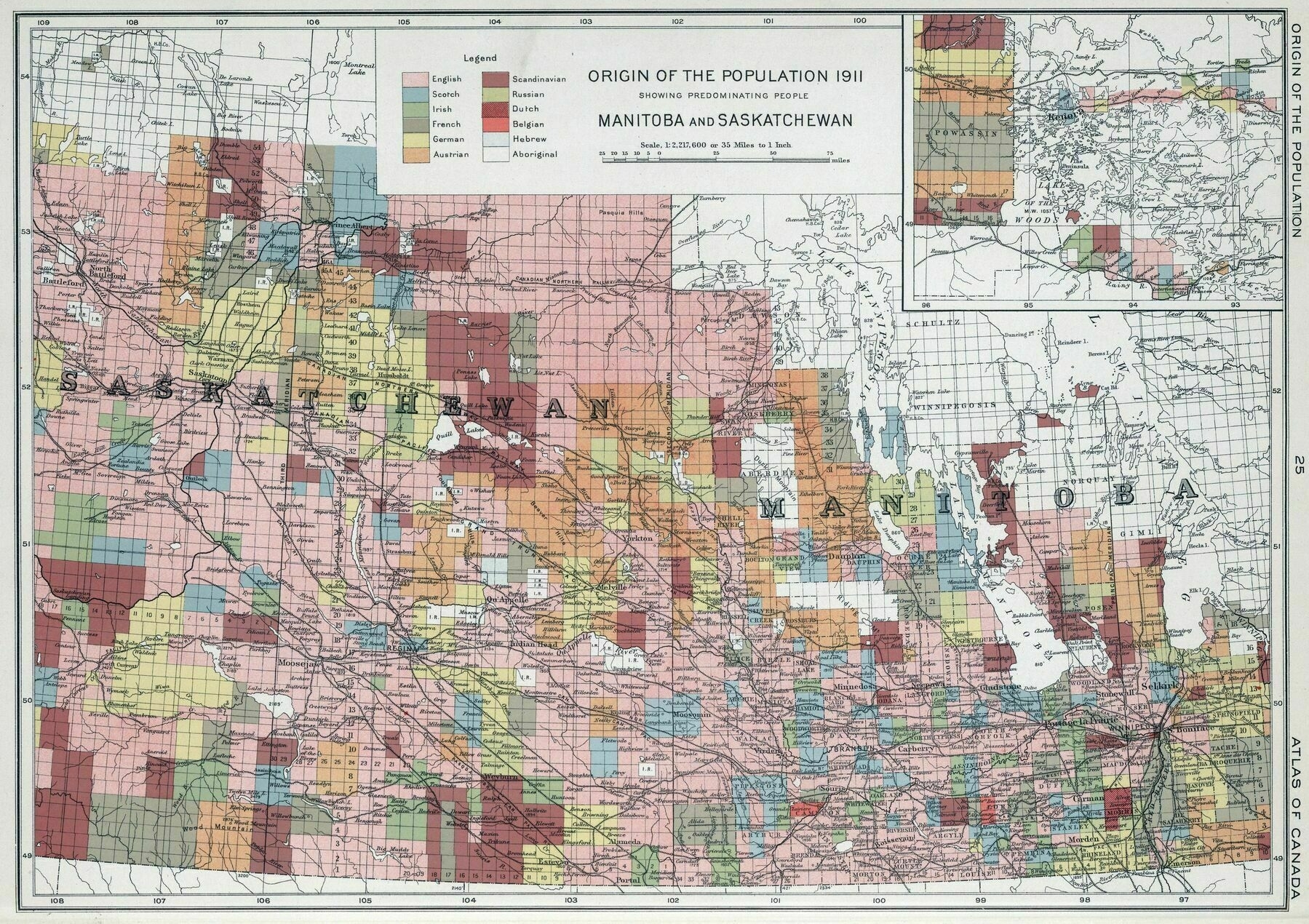
‘This is a REALLY cool map!
Maps like these are why I browse this sub, thank you’
Ethnic map of Romania according to the 1930 census
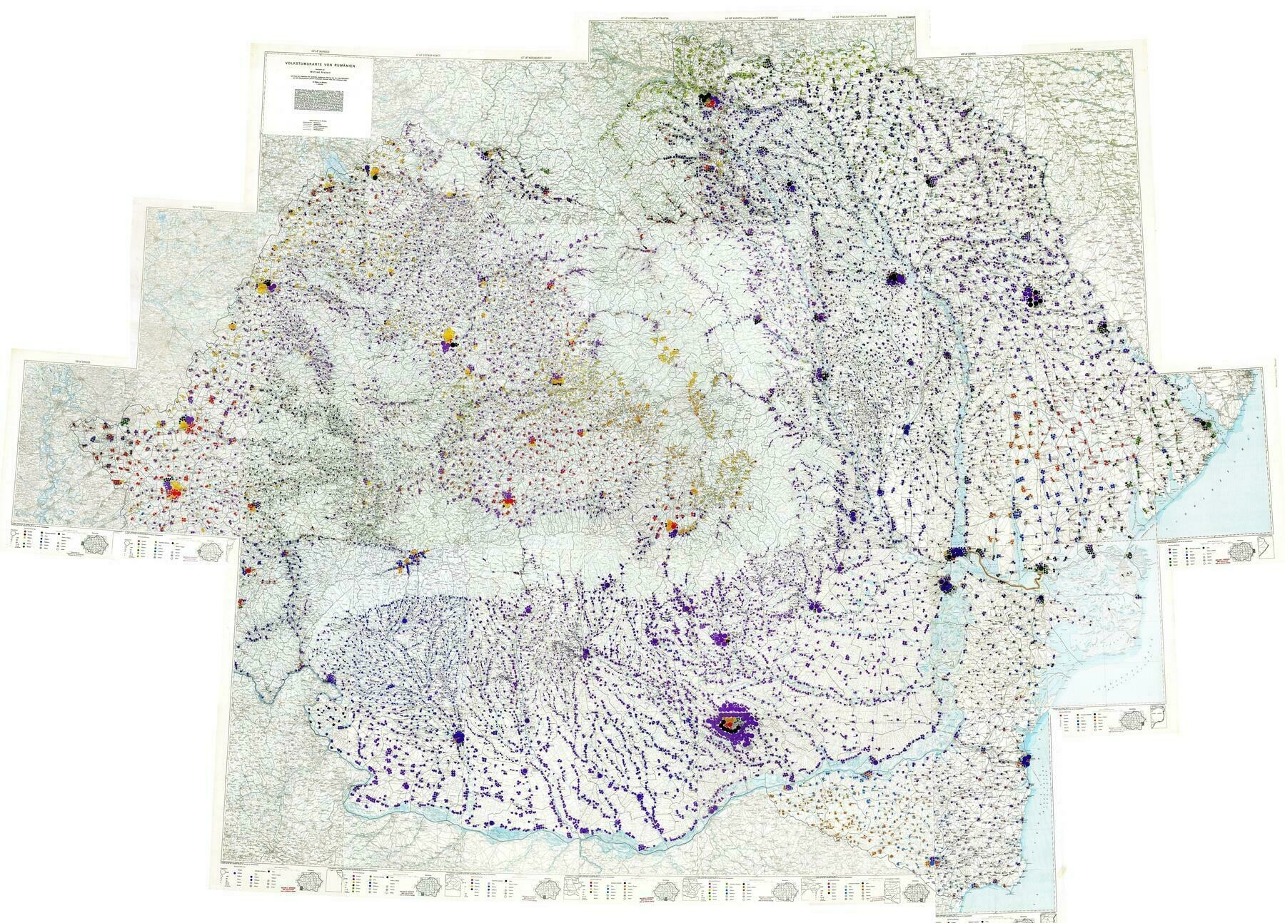
Red- German
Purple/Dark Blue - Romanian
Yellow/Orange - Hungarian
Dark Green - Russian
Light Green - Ukrainian
Blue - Bulgarian
Black - Jewish
Orange - Turks/Tatars/Gagauz
‘Ethnic map of Romania edited by Wilfried Krallert based on the results of the official Romanian census of ethnicity from 1930 (The general census of the population of Romania 1930, Vol. II, Bucharest 1939)’
Ethnicities of Malaysia from the 2020 census (Malay, Non-Malay Bumiputera [indigenous tribes], Chinese, Indian)
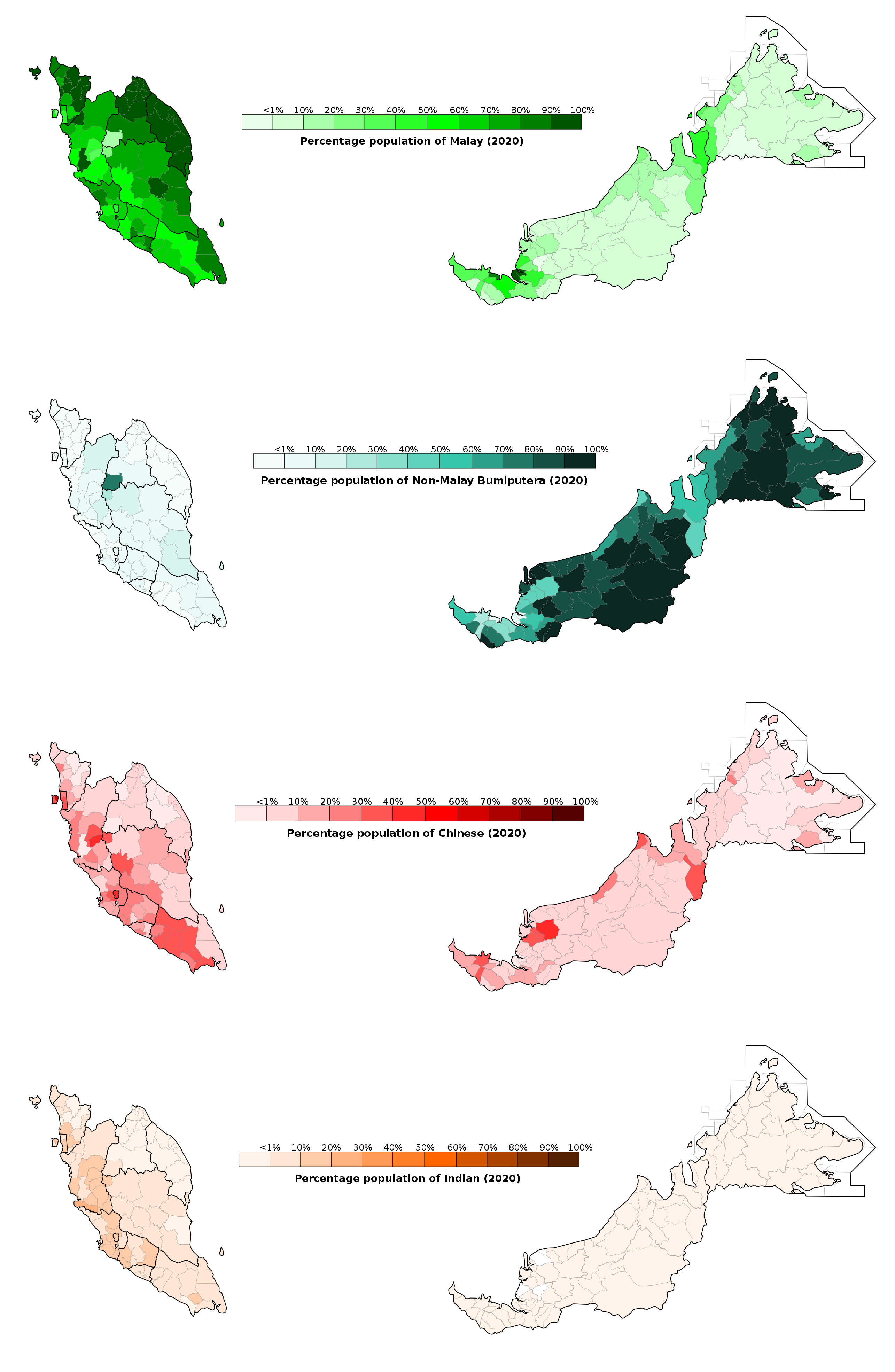
‘Does Bumiputera translate to ‘children of the Earth’? Do indigenous people come under that group?
All “indigenous” peoples, including Malays, are counted as “Bumiputera” in Malaysia, and that’s probably why the second map features “non-Malay Bumiputera”. And yes, it’s translated as “son of the earth/land/soil”’
Foreign born populations in London boroughs, 2021
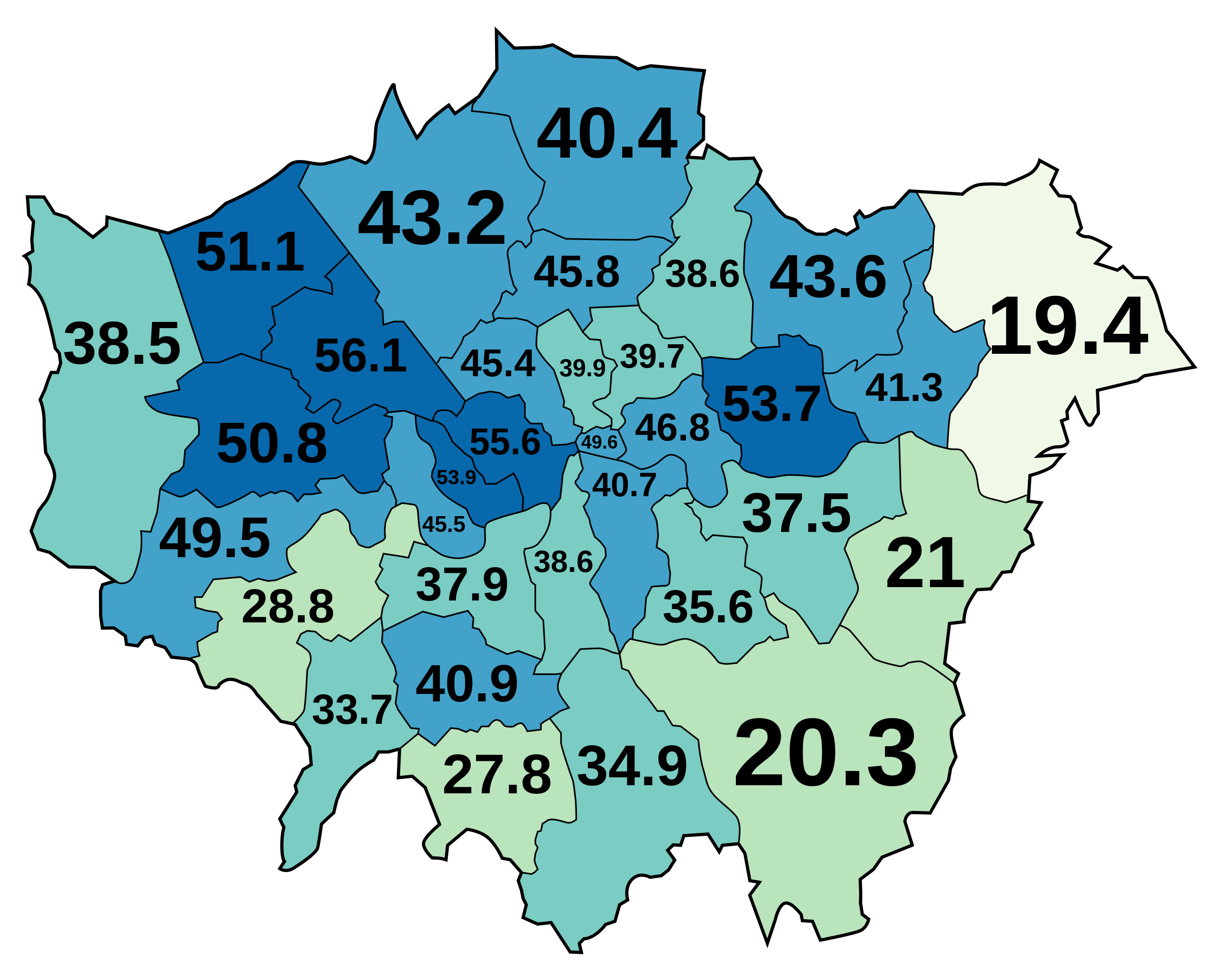
‘Those are so much higher than I would have thought
Welcome to Western Europe
I feel like there’s no unbiased way to understand immigration in Europe. People are hysterical or hysterical about the hysteria’
Ethnicity of New Zealand regions (European, Maori, Asian, Pacific peoples) in 2018
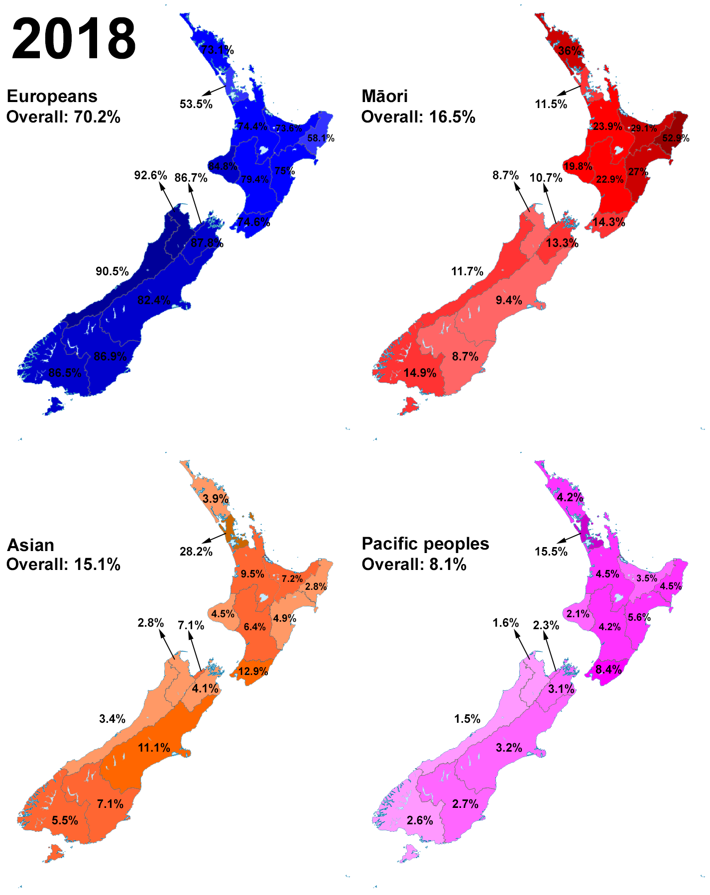
‘Maori are Pacific people, could they be double counting somewhat?
My great-aunt is Māori. She married a Cook Islander. So her kids are counted on the census as Māori and as Cook Islander. My mum is Māori. My dad is white. So I’m counted on the census as Māori and as New Zealand European. We don’t do blood quantum or mixed race stuff here. The way I see it, I’m me, and I’m Māori and NZ European, so I’m 100% Māori and 100% NZ European’
Ethnographic Map of Great Britain and Ireland, according to Dr. Gustaf Kombst - by A.K. Johnston (1850)
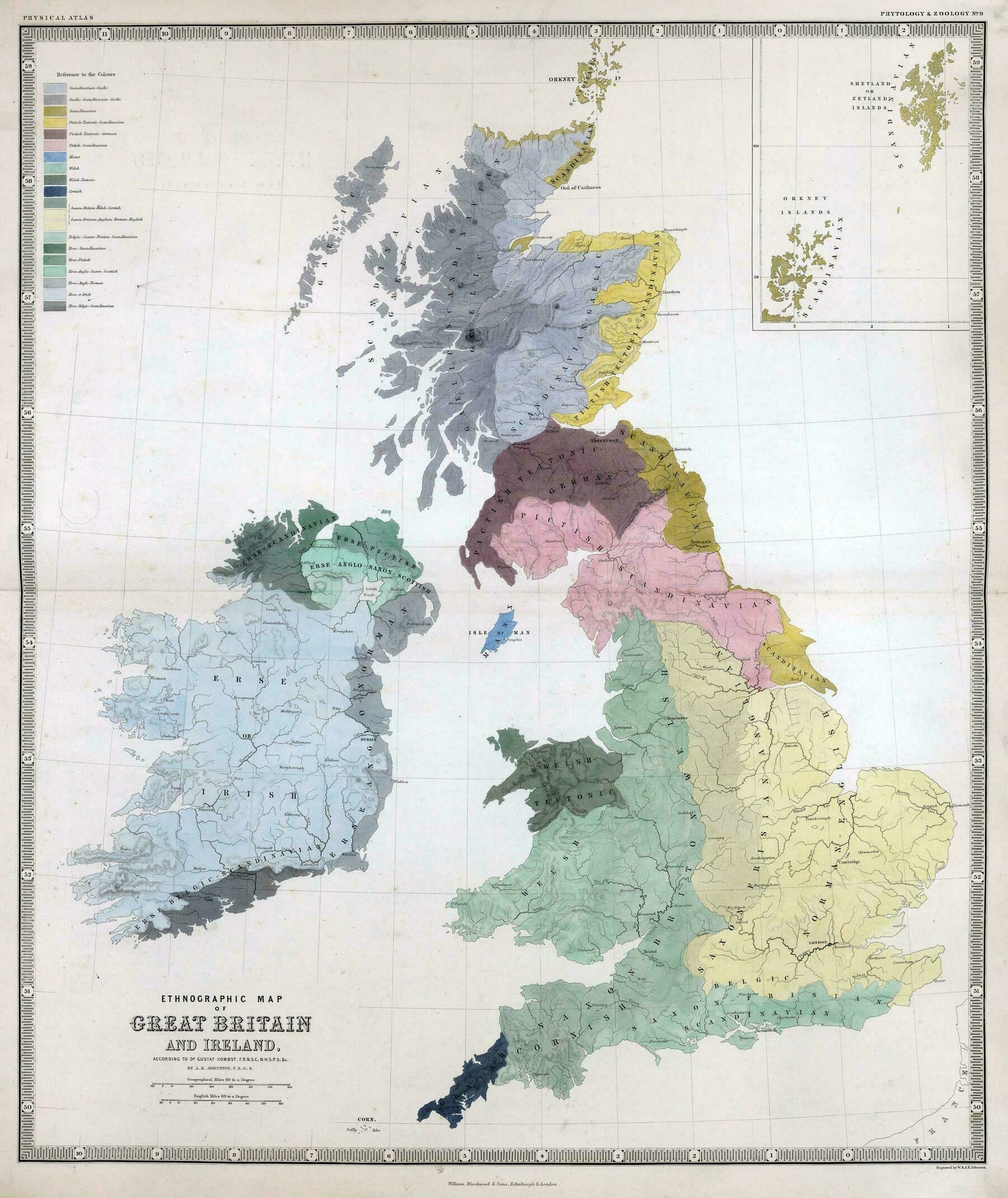
‘This is fantastic! Very good work here.
It should be noted however that this is primarily a cultural influence map, as the amount of DNA contributed by Scandinavians (and likely even Angles and Saxons) was pretty minor compared to the people that lived here previously. The days where conquerers would replace populations was long over at this point, they just took over the positions of power and influence at the top of society.
So are you saying that a DNA based map would look significantly different?
I’ve done a little research into this (for genealogy purposes), and believe that the majority of the DNA in Britain is still pre-Celtic and Celtic. Later waves of conquerers (northwest Germanic Angles, Saxons, Jutes, Frisians), Scandinavians (mainly Danish with some Norwegian), and Norman (mostly French) only contributed a minority part of the genetics to the current population. The new groups that came in usually just took over the upper echelons of power and privilege in society, so their cultures kind of became more of an influence (or dominant), but the DNA they contributed overall wasn’t very large.
If I had to estimate, it would be around: 40% Pre-Celtic 40% Celtic 15% Anglo-Saxon 1% Viking 1% Norman
3% other’
Slovenians in Slovenia (1981)
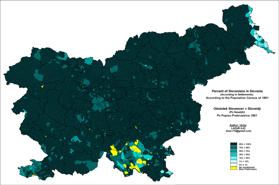
‘Ok, I’ll bite:
What on Earth is up with all those areas around Kočevje with either very low percentage of native population, or “No Inhabitants”??
The region around Kočevje was the settlement area of the Gottscheers. They were resettled in WW2 and were not allowed to return so their villages are now mostly overgrown or demolished.
But it seems that many of the populated places there still have a low percentage of Slovenians, despite the Germans being deported. Who was settled in their place?
A few hundreds Germans were not deported and are still living there. The remaining villages there are so small however, that probably just a couple of Germans would significantly change the percentages. As far as I know only a couple of places were repopulated like the town Kocevje.’
Ethnic map of Slovenia according to the 1981 population census
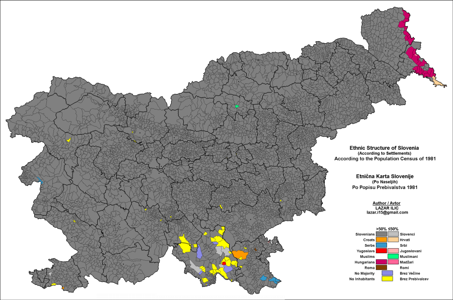
‘Surprised there aren’t any Germans
Austrian here. Whilst much of now slovenia used to be part of austrian regions in imperial times, they were populated by slovenes, there were maybe minor german people in the cities and some in the south.
Rather there are slovenes in austria now, and there used to be many more, they only form the majority in one tiny county now (Zell in Carinthia) but the slovenes have City names for everything in carinthia.
The more surprising thing is the lack of italians here, i have lived in slovenia and you will definitely hear loads of italian on the coast
There was one distinct area where Germans formed a majority since the middle ages, the Gottschee county. Germans there were well integrated, (for example the author of the well known map of United Slovenia, Peter Kozler, was a Gottscheer) and for the most par did not want anything to do with the Nazi regime, but the Communists used them as an easy scapegoat and expelled all of them. However, it is also true that Carinthia, which was about 40% Slovenian in the middle of 19th century, is now almost completely Germanized due to harsh discrimination and pressure against Slovene language, which only lessened in the last few decades.
Unlike the Germans, Italians left voluntarily and were not expelled, although their fear of the new communist regime was not unfounded. However, what is not so well known is that up to a half of these Italians were no Italians at all, but Slovenes and Croats who opposed Communism and had to flee. In their place, many communist loyalist from southern parts of Yugoslavia were settled. Today, about 1/3 of the population in the Coastal miunicipalities in Slovenia is of non-Slovene descent.’
1878 ethnographic map of European Russia - by Aleksandr Fyodorovich Rittikh
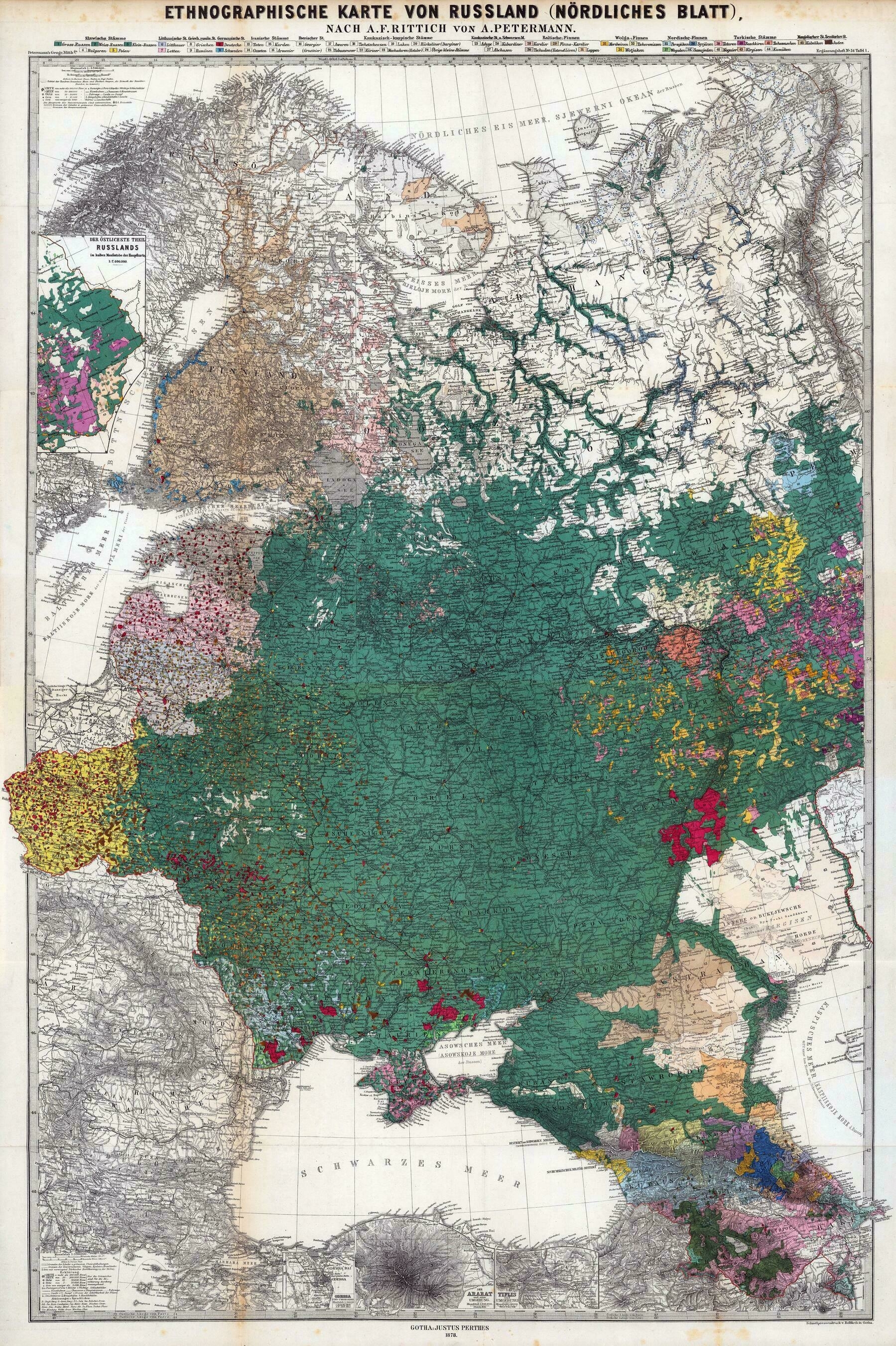
‘I recognize Volga Germans, Bessarabia Germans and Crimean Germans
Germans were a significant minority in almost all parts of Eastern Europe’
Ethnicities of Slovakia (Slovaks, Hungarians, Rusyns, Roma) - based on the 2021 census
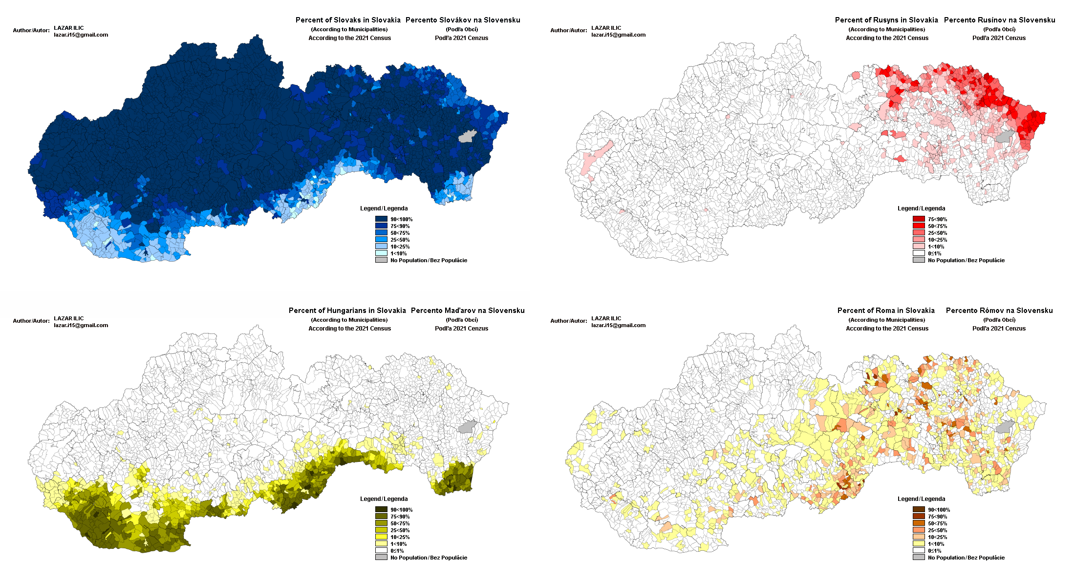
‘Love to see the Rusyn ethnicity represented. A micro Slavic ethnicity that developed in the mountainous region between Slovakia/Poland/Ukraine.
For more information please see the Wikipedia entry.
They are a very controversial “ethnicity” however, as Ukrainians claim they are just Ukrainians living in Slovakia, which is a claim Slovaks tend to take great offense at.
Indeed, the Transcarpathian Slavs that used to be called Rusyns during the time of the Austro-Hungarian Empire were also one of if not the most radical groups that participated in the Ukrainian liberation movement in the early 20th century.
The languages are also identical as far as I can tell. They have some distinct dialectal vocabulary, but this is not specific to “Rusyn language” but just Transcarpathian dialects of Ukrainian.
Also, in the 18th and early 19th centuries, before the term “Ukrainian” was invented, speakers of the Ruthenian language (which split into Ukrainian and Belarusian) called themselves, you guessed it, Rusyns or sometimes Rusnaks.
I’m just saying all of this so you can judge for yourself. Of course, at the end of the day, it’s up to the Slovakian Rusyns themselves how they choose to identify, but in my limited experience they seem to be quite ambivalent in regards to the matter, unlike Slovakians for some reason.’
Ethnographic map of Hungary, according to the census of 1910 - by Paul Teleki
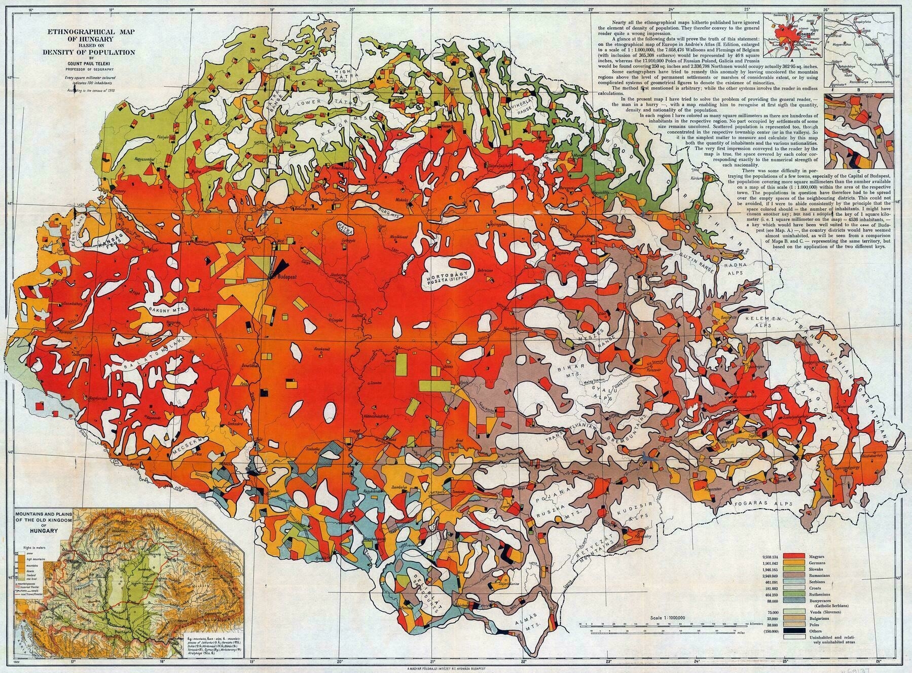
‘Tbh it was even more fair now that I look at it on a redmap
That’s because you vaguely recognise the new shape of Hungary in the main Red area, but don’t see that the new state borders were drawn on average 50 kms inside the red area. As a result over 2 million Hungarians living in majority Hungarian regions found themselves outside of Hungary overnight, without ever being asked. Almost all these parts were annexed to the successor states because of strategic considerations, fertile agricultural land in the case of Southern Czechoslovakia, important railway junctions in most other cases. Despite being overwhelmingly Hungarian. So much for “national self-determination”
The other 1.5 million Hungarians lived further from the new borders, 0.5 millions of them Transylvanian Szeklers, the remaining 1 million in smaller enclaves, or completely dispersed.
Or consider that the 3 million Romanians received a bigger chunk territory (103K km2) when already having their own country, than what was left for 10 million Hungarians (93K km2). Yeah, super fair.
Plus, but this is hindsight of course, basically all successor states treated their minorities far worse than Austro-Hungary ever did.’
Dissemination of the Germans in Europe - by Paul Langhans (1894)
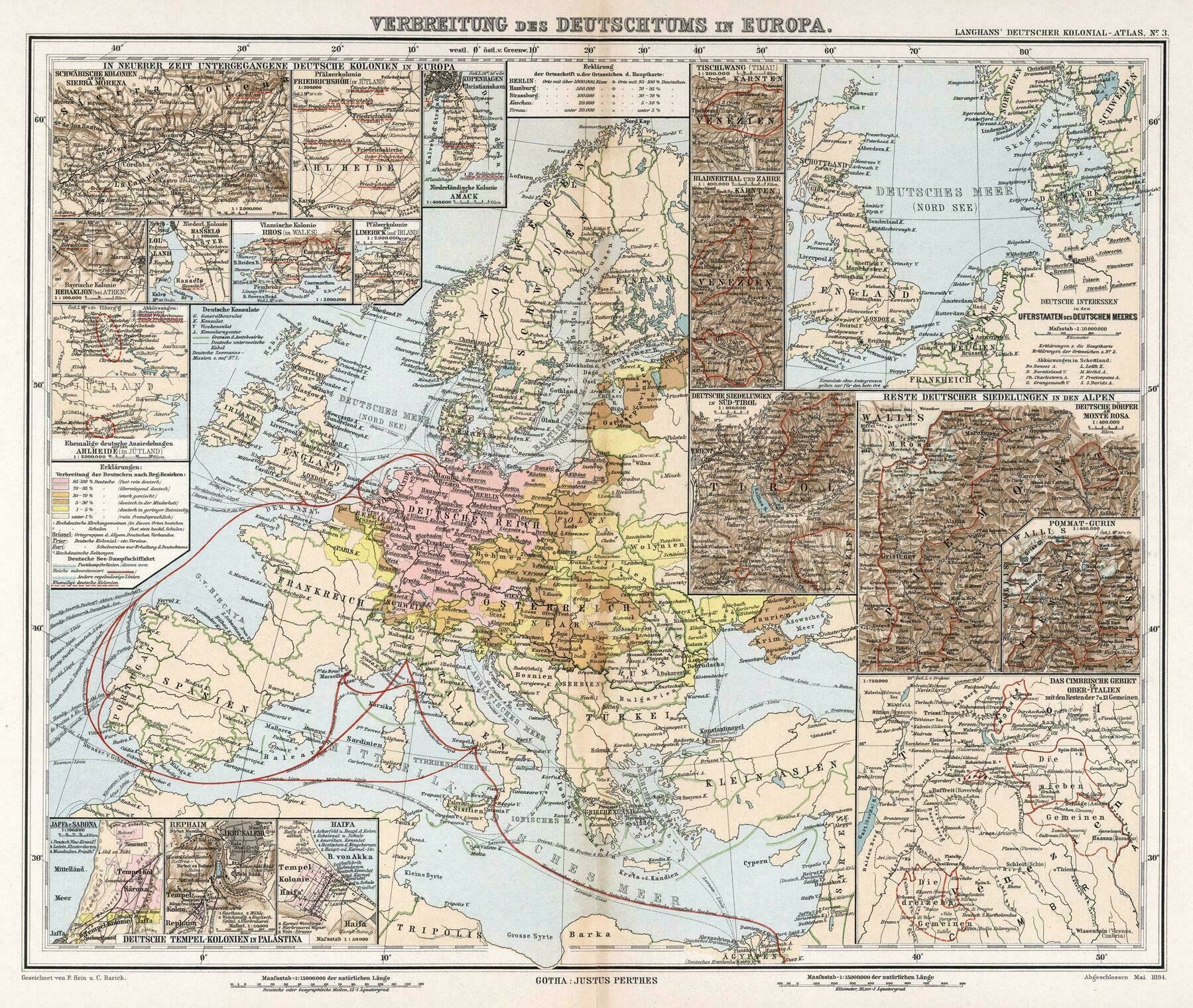
‘That’s a nice map’
Percentage of the Tutsi ethnic group in communes of Rwanda in 1983
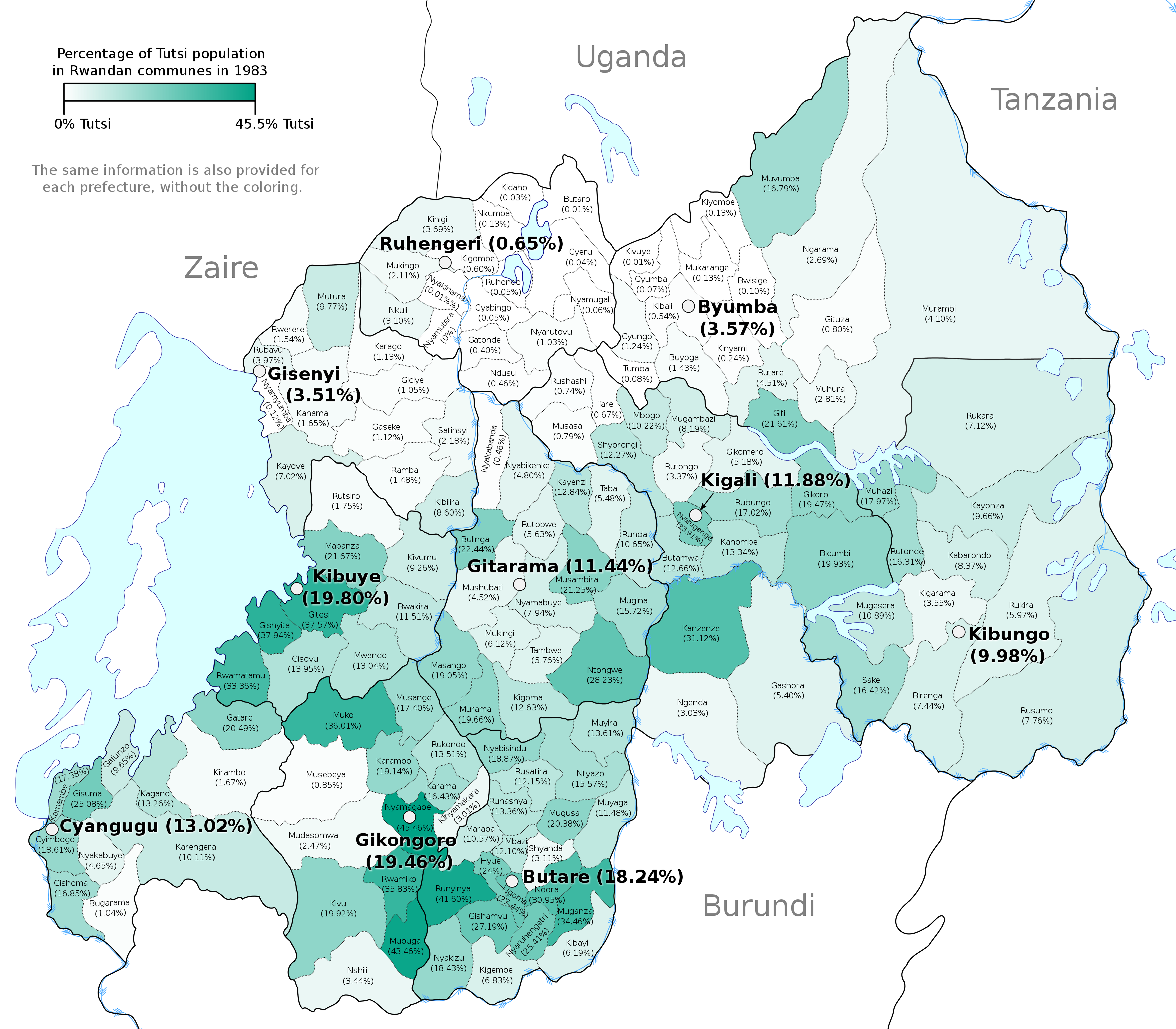
If you call anyone Tutsi or Hutu in Rwanda, they will put you in jail, because the now ruling Tutsi elite want to deny the fact that it’s the Tutsi who are the ruling class. It even spread to Wikipedia. There is distinction between how the articles are written for Rwanda and Burundi.
Can you give an example of it spreading to Wikipedia?
I take it back, the power of wiki, the article has found its equilibrium as opposed how it used to be, who ever has edited it has done an excellent job.
Rwanda has been a unified state since pre-colonial times,[43] and the population is drawn from just one cultural and linguistic group, the Banyarwanda;[252] this contrasts with most modern African states, whose borders were drawn by colonial powers and did not correspond to ethnic boundaries or pre-colonial kingdoms.[253] Within the Banyarwanda people, there are three separate groups, the Hutu, Tutsi and Twa.[254] The CIA World Factbook gives estimates that the Hutu made up 84% of the population in 2009, the Tutsi 15% and Twa 1%.[72] The Twa are a pygmy people who descend from Rwanda’s earliest inhabitants, but scholars do not agree on the origins of and differences between the Hutu and Tutsi.[255] Anthropologist Jean Hiernaux contends that the Tutsi are a separate race, with a tendency towards “long and narrow heads, faces and noses”;[256] others, such as Villia Jefremovas, believe there is no discernible physical difference and the categories were not historically rigid.[257] In precolonial Rwanda the Tutsi were the ruling class, from whom the kings and the majority of chiefs were derived, while the Hutu were agriculturalists.[258] The current government discourages the Hutu/Tutsi/Twa distinction, and has removed such classification from identity cards.[259] The 2002 census was the first since 1933[260] which did not categorise Rwandan population into the three groups.[261]
Romanians in Romania by counties (1930-2011)
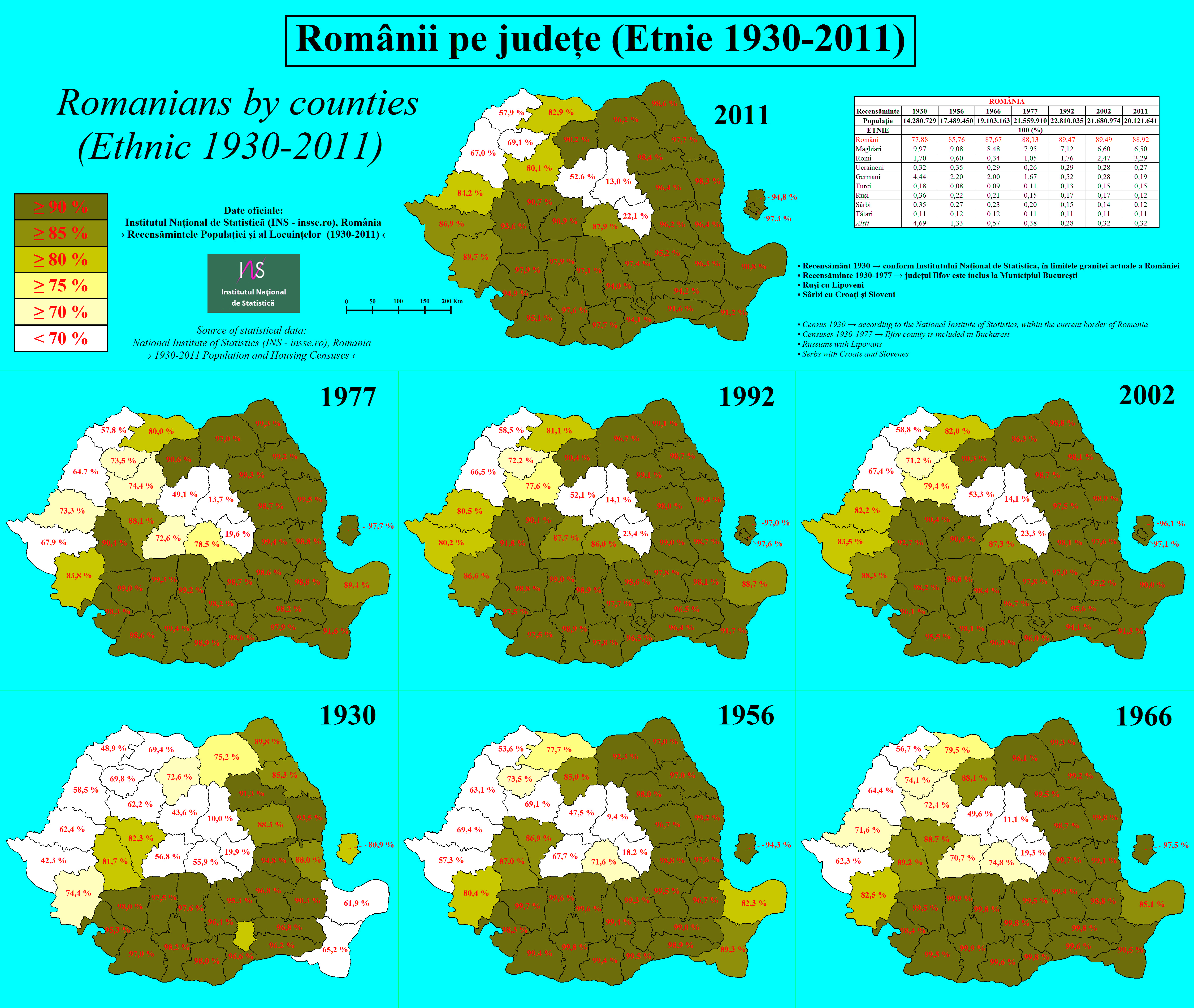
‘Romania has counties?
I mean, it has count Dracula, so makes sense somehow…
The word in Romanian is județ, which means “jurisdiction”. English speakers (by which I largely mean English-speaking Wikipedians) have this obnoxious habit of using “county” for anything in the world that vaguely resembles a British or American county, ignoring the anomalous development of that term among the English.’
1887 ethnographic map of Asia - by Vinzenz Haardt
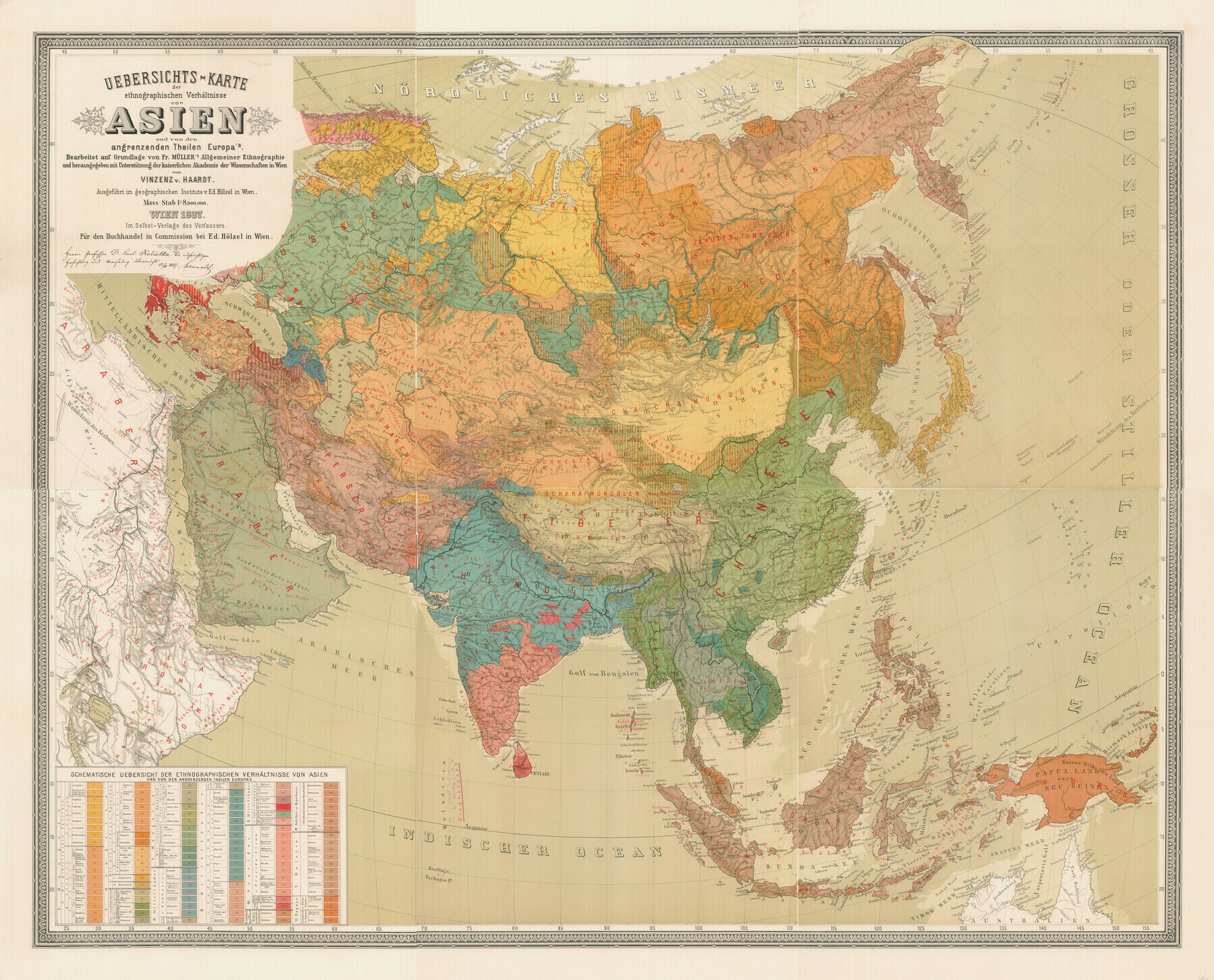
“There is a lot going on in NE Asia at this time.
Russia is settling the Amur Valley - they’ve only had fur trading posts in the East up until the late 19th c.
Largely in response to Russian annexation of Outer Manchuria, Japan decides to aggressively settle Hokkaido, most of which was either empty or settled only by Ainu before that.
In Inner Manchuria, the Manchurians are in the process of being Sinicized.
etc…”